Monument Announces Mineral Resource on Alliance/New Alliance areas of Murchison Gold Project
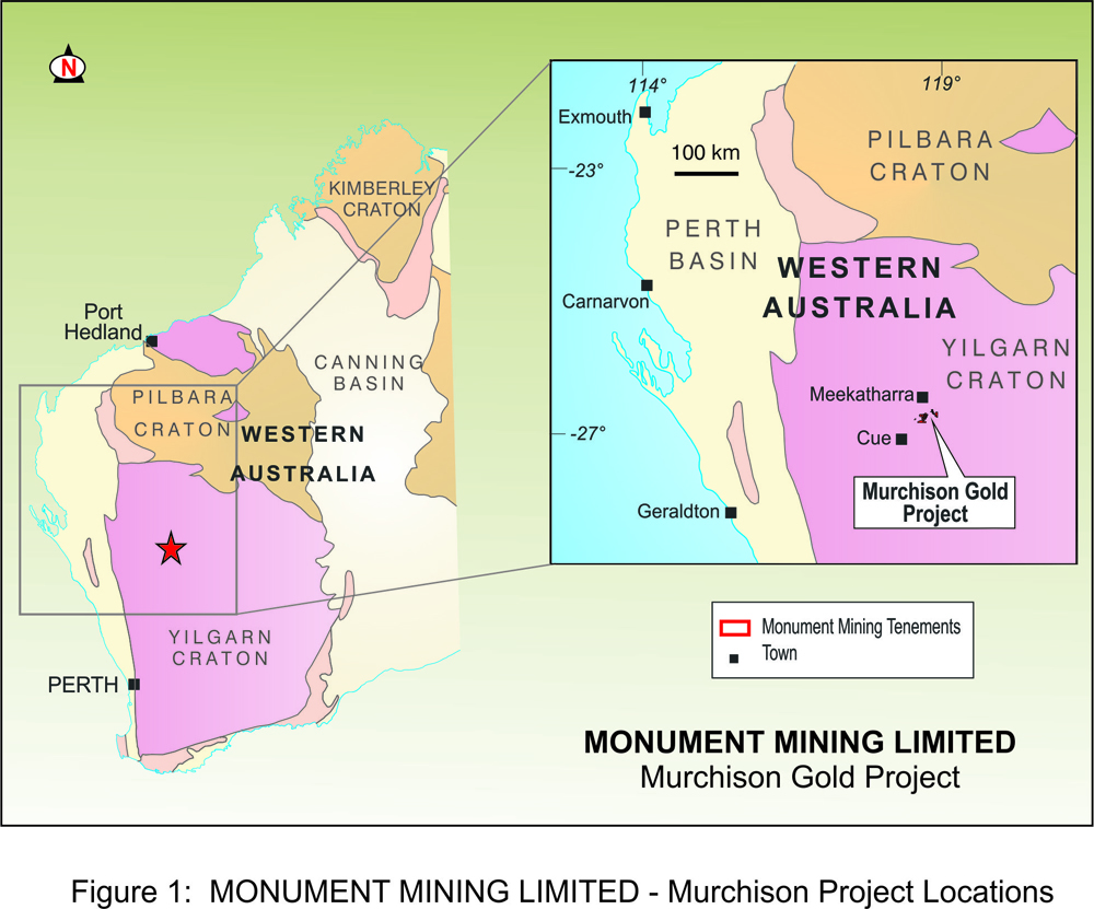
Vancouver, B.C. Monument Mining Limited (TSX-V: MMY and FSE: D7Q1) (“Monument” or the “Company”) is pleased to announce a mineral resource estimate for the Alliance/New Alliance areas of the Murchison Gold Project in Western Australia, which has been prepared in accordance with the requirements of National Instrument 43-101 (“NI 43-101”). The Murchison Gold Project is 100% owned by Monument Mining Limited through its wholly-owned Australian subsidiary, Monument Murchison Pty Ltd., and consists of the historical Burnakura and Gabanintha Projects. Figure 1 (Appendix 1) shows a Location Plan for the Project.
CEO, Robert Baldock, said: “An Inferred and Indicated Mineral Resource Estimate for the Alliance/New Alliance deposits has been received (21/1/2015) from Independent Resource Consultants, Cube Consulting Pty Ltd, after incorporating the results from the first 102 holes drilled. Using a 1.0g/t Au grade cut-off, an Indicated Mineral Resource of 1.13 Million Tonnes @ 2.2g/t Au for 80,400 ounces and an Inferred Mineral Resource of 5,000 tonnes @ 2.2g/t Au for 3,200 ounces has been reported. This represents a 90% increase in the Indicated gold ounces as compared to the historical estimate inventory, as a result of improved confidence in the grade continuity of the infill and extensional drilling completed by Monument. The total contained gold ounces have increased by 15% as compared to the historical resource for the project. This represents a very positive initial outcome toward the preparation of a preliminary economic assessment in respect of the Alliance/New Alliance deposits. The company is now undertaking a continuing program of ongoing exploration over the remainder of the historical resources that were acquired in February, 2014.”
Alliance/New Alliance Mineral Resource Estimate
Table 1 below shows a breakdown of the updated Mineral Resource estimate at a 0.5g/t cut-off:
Table1. Mineral Resource for Alliance and New Alliance at a 0.5g/t Au cut-off
| Deposit | Indicated | Inferred | ||||||
| Density | Tonnes | Au | Contained Au | Density | Tonnes | Au | Contained Au | |
| (g/cm3) | (Mt) | (g/t) | (Koz) | (g/cm3) | (Mt) | (g/t) | (Koz) | |
| Alliance | 2.3 | 0.64 | 2.5 | 50.8 | 2.5 | 0.02 | 1.4 | 0.7 |
| New Alliance | 2.3 | 1.24 | 1.2 | 47.6 | 2.7 | 0.08 | 1.5 | 3.7 |
| TOTAL | 2.3 | 1.88 | 1.6 | 98.4 | 2.6 | 0.10 | 1.5 | 4.4 |
Table 2 below shows a breakdown of the updated Mineral Resource estimate at a 1.0 g/t cut-off:
Table 2. Mineral Resource for Alliance and New Alliance at a 1.0g/t Au cut-off
| Deposit | Indicated | Inferred | ||||||
| Density | Tonnes | Au | Contained Au | Density | Tonnes | Au | Contained Au | |
| (g/cm3) | (Mt) | (g/t) | (Koz) | (g/cm3) | (Mt) | (g/t) | (Koz) | |
| Alliance | 2.3 | 0.49 | 3.0 | 47.4 | 2.7 | 0.01 | 3.0 | 0.5 |
| New Alliance | 2.3 | 0.65 | 1.6 | 33.0 | 2.7 | 0.04 | 2.1 | 2.7 |
| TOTAL | 2.3 | 1.14 | 2.2 | 80.4 | 2.7 | 0.05 | 2.2 | 3.2 |
The Company is working towards an economic understanding of the revised resource model and estimate, with a view to a commercial outcome; however, the Mineral Resource has not demonstrated economic viability at this stage. All tonnage, grade and ounces have been rounded to reflect the relative uncertainty and the approximate quality of the estimate.
The full technical report, prepared in accordance with NI 43-101, will be filed on SEDAR and the Company’s website within 45 days of the issuance of this news release.
Background on Alliance/New Alliance Deposit
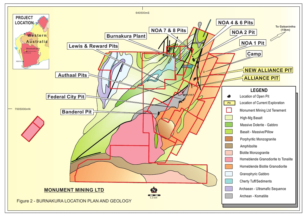
The Alliance and New Alliance open pits lie approximately 2 kilometres to the south of the NOA line of open pit and underground workings. Two tenements, M51/116 and M51/117, cover the Alliance and New Alliance deposits, which have been mined intermittently since the 1980’s for shallow oxide gold mineralization to a 60-80 metre in vertical depth. Mineralization occurs within narrow, moderate to steeply dipping shear zones that extend beneath the current pit limits. Figure 2 (Appendix 2), shows a layout of the Burnakura project and geology.
Gold mineralization at Alliance and New Alliance occurs over a 1,150 metre strike length. The mineralization exists within several north to north-east trending, moderately east dipping (~30°) quartz zones with an average true thickness varying from 2 metres to 5 metres.
The Alliance mineralization is hosted within narrow quartz veins developed along the upper contact of a number of thin banded iron formation units and are associated with shearing. Higher grade gold mineralization occurs within quartz veins in dilational sites that have developed along reactivated thrust faults.
Historical Estimates
Several historical estimates have been completed by various consultancies between 2011 and 2013 within the Project area using different methodologies to estimate the remaining resources beneath and along strike from the mined pits. After it acquired the project, Monument undertook drilling to confirm and extend the resource, and has standardized and verified the data in a secure relational database for mineral resource estimation.
Comparison of the Mineral Resource to the historical estimate, as determined by BM Geological Services (Murchison Gold Project: Burnakura and Gabanintha resource inventory (December 2013), at a 1.0 g/t Au cut-off, shows the Monument drilling has resulted in a significant increase in the Indicated gold ounces by 90%, based on the closer spaced drilling confirming confidence in the grade continuity. The total resource gold ounces have increased by 15% to 83,600 gold ounces when compared to the historical estimate. Refer to the Company’s news release of January 7, 2014 for further information regarding this historical estimate, including comments on its relevance and reliability.
QAQC and Resource Model
Monument has implemented external Quality Assurance and Quality Control (“QAQC”) processes to monitor the reproducibility of the drilling assay data. This system has been implemented during the resource drilling programs to monitor assay sample data for contamination, accuracy and precision. All historical and current drilling data have been validated and managed by Cube Consulting Pty Ltd. (“Cube”) in a secure relational ‘Structured Query Language’ server database system to ensure data integrity and security.
The sample collection and preparation, analytical techniques, security and QAQC protocols implemented by Monument for the Project are consistent with standard industry practice and are suitable for the purpose of mineral resource estimation and the reporting of exploration results to Canadian NI 43-101. Appendix 3 shows a list of the Mineral Resource Estimation Notes from Cube.
Mineralization at Alliance/New Alliance has a strong geological control with visual mineralization boundaries consisting of narrow high grade quartz zones within lower grade altered BIF halos. To effectively control the influence of the high grade gold values within and adjacent to the quartz veins, the geological volume modelling and estimation of the individual narrow quartz veins and broader BIF units was completed separately.
The resource model completed by Cube has utilised the validated Monument drilling database, comprising a total of 46,702 m of RC and diamond core drilling in 767 holes covering the Alliance / New Alliance deposits. The resource delineation and verification drilling completed by Monument during 2014 comprises 16% of the total mineralised drill intercepts used for the Mineral Resource estimation. Drilling was generally orientated east-west, with an average drill spacing of 10m by 10m at Alliance and 10m by 20m at New Alliance.
Resource Methodology and Estimate
A three-dimensional geological interpretation was completed by Cube to establish the underlying controls on gold mineralization and to incorporate the structural interpretation based on historical pit mapping.
Wireframe models of the quartz veins, BIF units and geological structures were constructed using SurpacTM based on all available drilling data as of 21st November 2014. Cube used 3 dimensional, spatially referenced pit mapping data, surface geological mapping and close space blast hole data to construct a robust geological framework for determining the most likely directions and extents of the grade continuity.
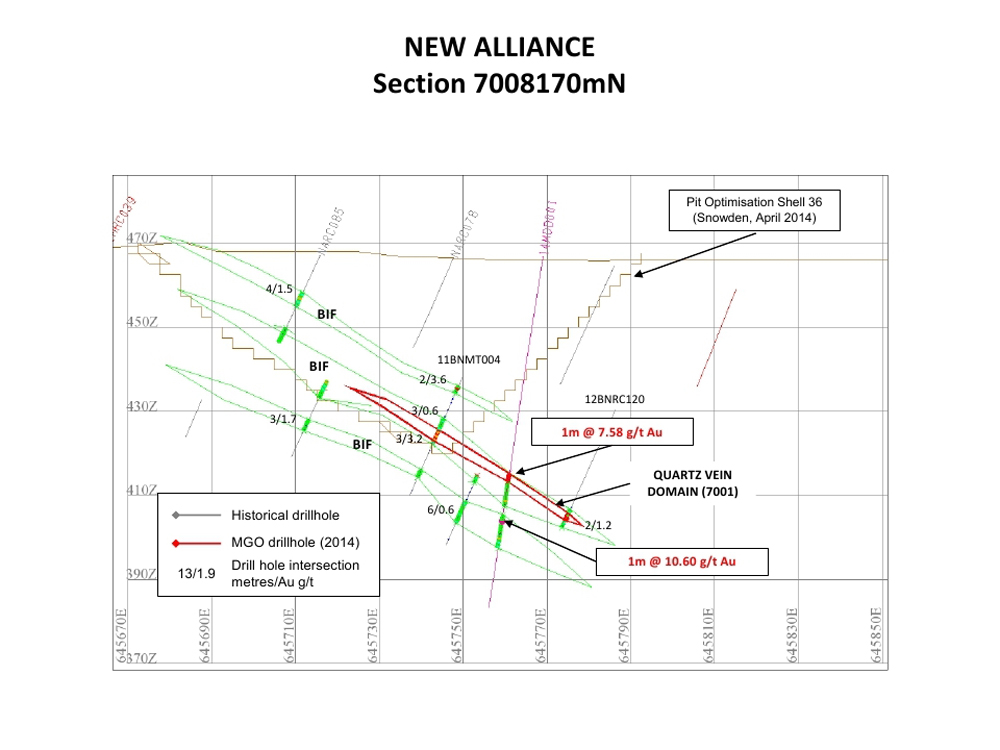
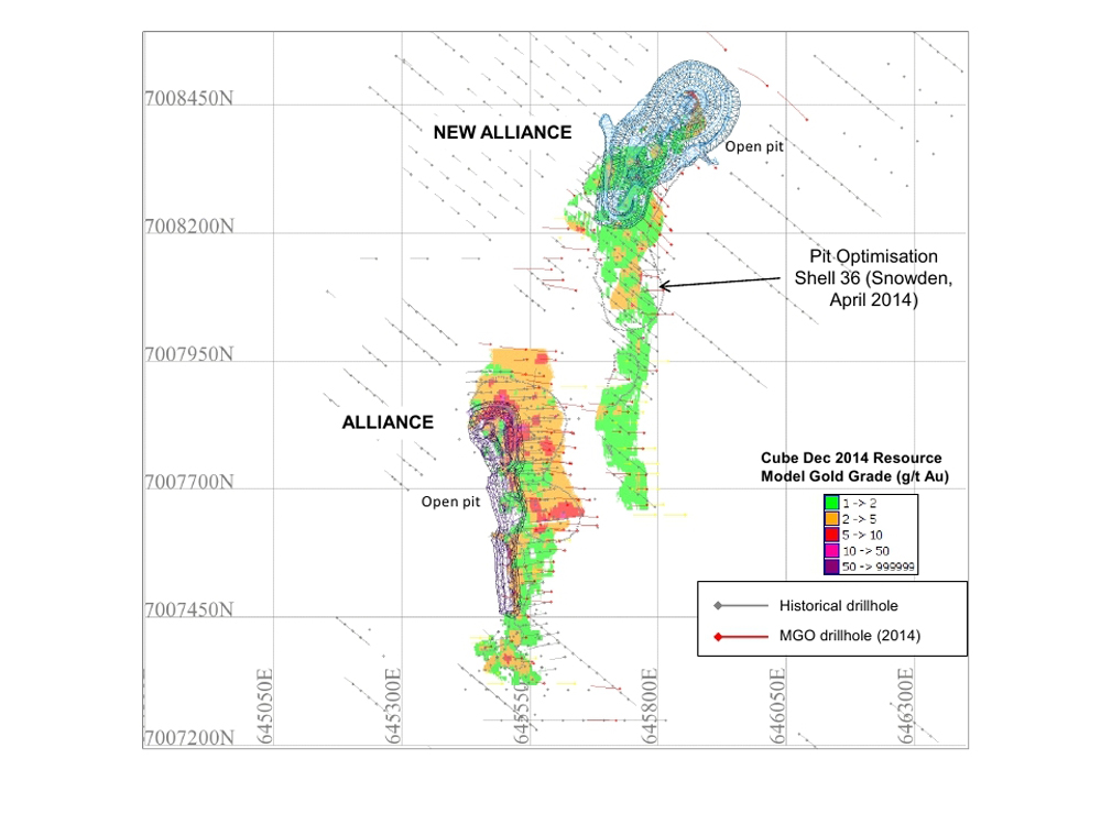
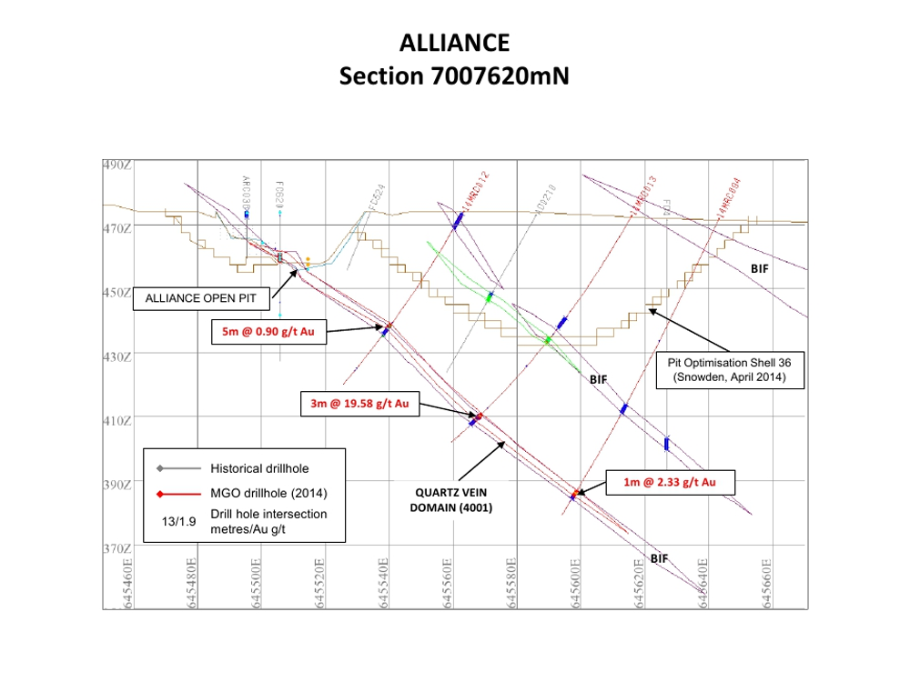
The drillhole data used for the Mineral Resource estimate included Diamond, Reverse Circulation and Aircore drillholes. Historical grade control drilling data (‘Blast Holes’) from open pit mining was not used for the resource estimation. Figure 4 (Appendix 4) shows a layout of Alliance and New Alliance with historical and current drilling. Figure 5 (Appendix 5) shows a cross section of Alliance and Figure 6 (Appendix 6) shows a cross section of New Alliance.
The Alliance/New Alliance mineralised domains are considered by Cube Consulting to be of sufficient grade, geological continuity and drill density to support the classification criteria of Indicated and Inferred Mineral Resource as required for NI 43-101 compliance. Cube considered a range of criteria when addressing the suitability of the classification boundaries including: Confidence in geological, grade and volume continuity; drill data density, spacing and quality; estimation methodology; Kriging quality; and reliability of supplied depletion surfaces.
Qualified Person Statement
The scientific and technical information in this press release has been compiled by Lisa Wells (B.Sc App Science, MAusIMM), and reviewed and approved by Darryl Mapleson (BSc (Hons), FAusIMM) who is a Geologist retained by Monument Mining Limited and a Competent Person as defined by JORC guidelines and a Qualified Person for NI43-101. He has been working in Australia for Monument as an independent consultant.
Scientific or technical information in this news release that relates to the preparation of the Company’s Mineral Resource estimate is based on information compiled or approved by Adrian Shepherd. Adrian Shepherd is an employee of Cube Consulting Pty Ltd and is considered to be independent of Monument Mining Ltd. Adrian Shepherd is a chartered professional member in good standing of the Australasian Institute of Mining and Metallurgy and has sufficient experience which is relevant to the commodity, style of mineralisation under consideration and activity which he is undertaking to qualify as a Qualified Person under National Instrument 43-101. Adrian Shepherd consents to the inclusion in this report of the information, in the form and context in which it appears.
About Monument
Monument Mining Limited (TSX-V:MMY, FSE:D7Q1) is an established Canadian gold producer that owns and operates the Selinsing Gold Mine in Malaysia. Its experienced management team is committed to growth and is advancing several exploration and development projects including the Mengapur Polymetallic Project, in Pahang State of Malaysia, and the Murchison Gold Projects comprising Burnakura, Gabanintha and Tuckanarra in the Murchison area of Western Australia. The Company employs over 300 people in both regions and is committed to the highest standards of environmental management, social responsibility, and health and safety for its employees and neighboring communities.
Robert F. Baldock, President and CEO
Monument Mining Limited
Suite 1580 -1100 Melville Street
Vancouver, BC V6E 4A6
FOR FURTHER INFORMATION visit the company web site at www.monumentmining.com or contact:
Richard Cushing, MMY Vancouver T: +1-604-638-1661 x102 rcushing@monumentmining.com
Wolfgang Seybold, Axino GmbH T: +49 711-2535-92 40 wolfgang.seybold@axino.com
“Neither TSX Venture Exchange nor its Regulation Services Provider (as that term is defined in the policies of the TSX Venture Exchange) accepts responsibility for the adequacy or accuracy of this release.”
Forward-Looking Statements
This news release includes statements containing forward-looking information about Monument, its business and future plans (“forward-looking statements”). Forward-looking statements are statements that involve expectations, plans, objectives or future events that are not historical facts and include the Company’s plans with respect to its mineral projects and the timing and results of proposed programs and events referred to in this news release. Generally, forward-looking statements can be identified by the use of forward-looking terminology such as “plans”, “expects” or “does not expect”, “is expected”, “budget”, “scheduled”, “estimates”, “forecasts”, “intends”, “anticipates” or “does not anticipate”, or “believes”, or variations of such words and phrases or state that certain actions, events or results “may”, “could”, “would”, “might” or “will be taken”, “occur” or “be achieved”. Forward-looking statements in this news release include, without limitation, statements related to proposed exploration and development programs, grade and tonnage of material and resource estimates. The forward-looking statements in this news release are subject to various risks, uncertainties and other factors that could cause actual results or achievements to differ materially from those expressed or implied by the forward-looking statements. These risks and certain other factors include, without limitation: risks related to general business, economic, competitive, geopolitical and social uncertainties; all of the uncertainties inherent in resource estimates; uncertainties regarding the results of current exploration activities; uncertainties in the progress and timing of development activities, including uncertainties with respect to the preparation and completion of a preliminary economic assessment with respect to the Alliance / New Alliance deposits; foreign operations risks; other risks inherent in the mining industry and other risks described in the management discussion and analysis of the Company and the technical reports on the Company’s projects, all of which are available under the profile of the Company on SEDAR at www.sedar.com. Material factors and assumptions used to develop forward-looking statements in this news release include: , general economic factors and other factors that may be beyond the control of Monument; assumptions and expectations regarding the results of exploration on the Company’s projects; assumptions regarding the future price of gold of other minerals;; the expected timing and results of development and exploration activities; costs of future activities; capital and operating expenditures; success of exploration activities; mining or processing issues; exchange rates; and all of the factors and assumptions described in the management discussion and analysis of the Company and the technical reports on the Company’s projects, all of which are available under the profile of the Company on SEDAR at www.sedar.com. Although the Company has attempted to identify important factors that could cause actual results to differ materially from those contained in forward-looking statements, there may be other factors that cause results not to be as anticipated, estimated or intended. There can be no assurance that such statements will prove to be accurate, as actual results and future events could differ materially from those anticipated in such statements. Accordingly, readers should not place undue reliance on forward-looking statements. The Company does not undertake to update any forward-looking statements, except in accordance with applicable securities laws.
APPENDIX 1: Figure 1 – Murchison Gold Project
APPENDIX 2: Figure 2 – Burnakura Location Plan and Geology
APPENDIX 3: Mineral Resource Estimation Notes
1. The Mineral Resource estimate was undertaken by Cube Consulting Pty Ltd (“Cube”), a minerals industry consultancy based in Perth, Western Australia, which is independent of Monument Mining Limited.
2. The 2 deposits areas that are the subject of this Mineral Resource are located entirely on the Murchison Gold Project and the validated Mineral Resource drilling database for the estimated areas contained 32 diamond core (“DC”) drillholes (2,650m), and 735 reverse-circulation (“RC”) drillholes (44,052m).
3. The Mineral Resource estimate used only diamond core and RC drilling data, with no historical grade control drilling data included.
4. A total of 6 PQ diamond core holes (408.6m) and 103 RC holes (9,379m) were completed by MGO between 24/05/2014 and 9/09/2014.
5. Drilling was generally oriented on west-east lines, with MGO infill and extensional drilling to 10m x 10m spacings at Alliance and 10m x 20m spacings at New Alliance. The original historical drilling orientation for New Alliance was NW-SE on 20m oblique sections with current drilling now completed on west-east azimuths to ensure the mineralization is intersected perpendicular to the strike of the mineralization.
6. Collars for MGO drillholes used in the mineral resource estimate were surveyed by Real Time Kinematic (“RTK”) satellite navigation using a single reference base station by ABIMS Solutions. The differential GPS system is considered to provide up to centimetre-level accuracy.
7. Downhole surveys have been conducted by ABIM Solutions on all Diamond and RC holes drilled by MGO using a north seeking gyroscope survey instrument on 5m downhole increments.
8. Geological logging of MGO drillholes includes: lithology, weathering, oxidation, texture, alteration, veining style and percentages, mineralization minerals, structural defects and groundwater conditions. All drillhole logging data was compiled into a master drilling database.
9. MGO RC drilling was logged and sampled over regular 1m intervals for the entire hole, whilst DC holes were logged and sampled over varying intervals from 0.25m to 1.2m (average 0.96 metre sample length) according to geological observations. In the case of DC drilling, samples submitted for assay were half-core.
10. MGO DC drilling and RC drilling had good overall samples recoveries. Localised zones of poor sample recovery caused by wet drilling conditions were intersected and assessed for suitability for inclusion in the Mineral Resource estimation.
11. RC sample splitting was completed during drilling under the supervision of MGO personnel. In the case of wet RC drilling, the entire bulk sample was submitted to SGS for drying, and splitting of the assay sub-sample for analysis. MGO diamond core for the entire hole was boxed and transported to ALS Ammtec laboratory for sawing and sampling.
12. Sampling and sample submission was conducted by MGO in accordance with a quality assurance/quality control program which includes the use of certified reference materials for DC, and RC drilling and field duplicates for RC drilling.
13. All MGO drilling samples were securely bagged and assigned sample identification numbers prior to their transport to an accredited assay laboratory in Perth (W.A.) operated by SGS Mineral Services to international standards.
14. Gold content is determined by fire assay methods using a 50g charge, lead collection and an atomic absorption spectroscopy finish. Assay methods have a lower detection limit of 0.01 g/t Au.
15. Lithological and vein density from drillhole logging was primarily used to develop interpretations of the mineralised geological domains. 3D spatially referenced pit and surface mapping were used extensively to determine the directions of geological/grade continuity and structural offsets. Gold assays were used as a secondary determinant in the interpretations.
16. Lithology, mineralization, and weathering surfaces were interpreted in 3D by Cube using GEOVIA SurpacTM software.
17. Mineralised interpretations generally honour a nominal 0.3 g/t Au lower cut-off. The interpretation was not typically extended more than 25 m past the last drillhole intercept both along strike and down-dip. However, sectional interpretations were extended further than 20 metre on some sections in some sparsely sampled areas where the geological and grade continuity could be reasonably assumed.
18. Additional criteria of a minimum 2 metre downhole interval length, and the minimisation of internal dilution were considered during the interpretation of the mineralised gold domains. However, internal dilution was incorporated where required to preserve the overall continuity of the mineralised domains.
19. The mineralization interpretation consists of 3 individual quartz vein domains, and 11 BIF domains, defined by lithological, weathering and spatial characteristics.
20. The vertical extent of the interpreted mineral resource varies across the prospects with a maximum vertical of approximately 120m.
21. For the purposes of density determination, a total of 243 samples were collected from DC drilling across the prospects, with 49 samples (20% of total samples) falling within the mineralised domains. Samples were collected from oxide, transitional and fresh material, as well as from all the representative lithologies. A mean density value was derived and then assigned for each of the three weathering types and representative lithologies in the mineral resource estimate.
22. Two metre downhole composites were extracted from the assay database based on the mineralised wireframes and form the basis for statistical analysis, variography and grade interpolation.
23. Gold composites were analysed, statistically and spatially, on an individual domain basis to determine appropriate grade top-cuts. The top-cuts that were applied to selected domains were all above the 97th grade percentile. In general, the mineralization domains represent distinct geological and statistical populations and provide a robust basis for mineral resource estimation.
24. Variography was completed by Cube to analyse the spatial continuity of the gold composites within the major mineralised domains using ISATIS(r) software. The resultant variogram models were used to optimise search strategies (Kriging Neighbourhood Analysis) and ultimately for interpolation of gold values into the block model.
25. Ordinary-kriging methodology using GEOVIA SurpacTM software was used to perform the interpolation of gold values. All block estimates were based on interpolation into parent cells with dimensions of 5m x 10m x5m (XYZ) for each individual mineralised domain. No rotation on the block model was undertaken.
26. Interpolation search distances were based on the ranges derived from variography and varied from 40m to 140m, with relative nugget effects ranging from 30% to 40% for gold.
27. Using the optimised search strategies a minor volume (<0.02%) of blocks within Alliance did not meet interpolation criteria and remained un-estimated, these blocks were visually identified as being on the edges and at depth of mineralised domains. New Alliance utilised a second pass search strategy (factor of 1.5) during interpolation to minimise un-estimated blocks, whilst still applying appropriate search parameters.
28. Depletion of the block model was undertaken using surfaces supplied by MGO which adequately represent the mined pits. Depletion areas were coded into the block model, with areas of backfill also identified and given an appropriate density.
29. Upon completion of the block model, global mean comparisons of domain and composite values were undertaken followed by swath plots comparing the estimated gold values, composited raw (declustered) gold values, number of composites and estimated tonnage for every 20 metre cross-section on an individual domain basis. As well as statistical and graphical validations the block model was also visually validated on a sectional basis within GEOVIA SurpacTM software. A check estimation was also undertaken using a non-linear recoverable resource estimator, Local Indicator Kriging (LIK), based on a 2.5m x 5m x 2.5m (XYZ) SMU size. The check estimate served a dual purpose of testing the both the domaining approach and interpolation methodology (Ordinary Kriging) undertaken by Cube.
30. The Mineral Resource was classified as Indicated and Inferred according to CIM Definition Standards and NI43-101 reporting criteria. Factors considered when classifying the Mineral Resource included data density, geological and grade continuity, drill spacing and drill quality, application of an appropriate estimation methodology and consideration of local estimation bias.
31. The final ANA Mineral Resource Estimate block model, included all estimated mineralised domains. Blocks outside of the mineralised domains were assigned appropriate waste parameters. The block model was coded or assigned additional attributes including; prospect, weathering, lithology, density, domain code, depletion and resource classification.
Tonnage-grade curves were generated for a range of reporting cut-off grades, material types and by pit area (ie. Alliance and New Alliance).
APPENDIX 4: Figure 4 – Layout of Alliance and New Alliance with Historical and Current Drilling
APPENDIX 5: Figure 5 – Alliance Cross Section 7007620mN
APPENDIX 6: Figure 6 – New Alliance Cross Section 7008170mN